VI
VI EN
EN


Post:Lucia Nguyen.Image:Lucia Nguyen, Hoang Nam
The morning weather on the southwestern border was pleasant. We began our tour of Tra Su Forest in Tinh Bien District, An Giang Province.

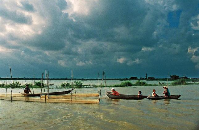
"Living with floods"
The boat traveled upstream on the Vinh Te Canal towards Chau Doc town and then into Tra Su. Upon reaching the heart of the flood zone, the canal banks were submerged in water, making it impossible to discern the shoreline. Along the canal were thatched houses precariously perched on the waves. During the dry season, the canal banks served as a transportation route for the local people. But now, the village roads and rice fields were all covered in a white expanse of water, and their only means of transport were small boats or motorboats.
If it weren't for the eucalyptus trees obscuring my view, I would feel like I was walking on the sea. The people here are used to "living with the floods." Both Vietnamese and Khmer people engage in many occupations during this season, such as fishing with nets, catching fish, and harvesting water lilies and wild sunflowers. This is a characteristic way of making a living for the people in the flood-prone areas, and also a unique cultural feature of An Giang. Along the way, I encountered many boats fishing with nets... The people in the flood-prone areas are searching for food in the floodwaters.
And in that vast expanse, where the sky and water meet, there is a plant that blossoms with clusters of bright yellow flowers under the sunlight, swaying in the wind, adding to the rustic beauty of the countryside during the flood season with its very simplicity: the water hyacinth - a characteristic plant and also an ingredient in traditional dishes of the people in the flood-prone areas of the Mekong Delta.


Tra Su Forest, a meeting place for birds
The natural landscape during the flood season is a very unique ecological feature of the Mekong Delta. It's a "common home" for birds, fish, and aquatic plants. The water surface in the forest is always covered with a thick layer of duckweed like a green velvet carpet, and above the melaleuca trees are tens of thousands of nests for birds, egrets, and other species, giving Tra Su a very unique character unlike any other forest. Seen from afar, Tra Su forest resembles a green oasis in a sea of white water. Tra Su forest is about 10km from the Cambodian border. We had to arrive at Tra Su before sunset. This month is when the sun sets fastest of the year and is also the most beautiful time to admire the beauty of the birds returning to their nests after a day of foraging. Tra Su melaleuca forest has a core area of 845 hectares and a buffer zone of 643 hectares. The only way into the forest that isn't flooded is the dike. You can explore Tra Su Forest in two ways: by land – on a tandem bicycle – and by water – by speedboat or canoe. We chose the speedboat. When the speedboat passed through a sparse forest area where many birds and egrets live, we switched to a canoe to avoid making noise that might disturb them. As the canoe weaved through the forest, I saw many bird nests on the branches of the melaleuca trees. The young birds lay in their nests, stretching their necks to watch our boat pass by, while the older birds were "chatting" with each other, a very pleasant sound. Amidst thousands of similar nests in the forest, after a long day, they returned to their own nests.

As we were walking, we suddenly heard a rustling sound, and a flock of birds appeared, covering the sky like a giant silver carpet stretching to the horizon. This was the time when the forest's "guests" were returning home, their flapping wings sounding like a small thunderstorm. I sat still, moved and speechless by this beautiful sight. After circling the forest by boat to admire the birds to our heart's content, we climbed the watchtower of the guard station, taking in the panoramic view of the forest in the evening, with white birds perched on the treetops, their calls echoing throughout the forest. Afterwards, we enjoyed local specialties of the flooded area: braised snakehead fish with tamarind sauce, grilled snakehead fish, and a delicious salad of water lilies and wild sunflowers.


The flood season is a very distinctive seasonal phenomenon in the Southwestern region of Vietnam. Water rises, inundating rice fields, houses, and the people of the area who diligently make a living amidst this vast expanse of water. This unique way of life has attracted many domestic and international tourists who come to visit and consider it a memorable experience.

| Additional information: + To participate in the flood season tour program, please contact: |