 VI
VI


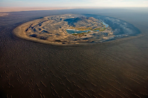
The name "Waw an Namus" in the local language means "mosquito oasis." This is because surrounding this deadly, ash-filled basin, there are still small, cool lakes with trees, attracting many mosquitoes.
 |
| A panoramic view of the "mosquito oasis". |
Since ancient times, the lakes surrounding these volcanic craters have been a source of fresh water and a peaceful resting place for weary travelers on their journey through the desert, from the city of Waw Al Kabir to the Al Kufrah oasis in southeastern Libya.

 |
| A lake that provides fresh water in the desert. |
Images of this volcanic basin were first captured by the civilized world thanks to Karl Moritz von Beurmann and Gerald Rohlfs, although they never actually visited the area, relying only on satellite imagery. It wasn't until a French soldier, Laurent Lapierre, was sent there on assignment that more accurate reports of the region were recorded.
About 11 years later, the Italian geologist Ardito Desio arrived at Waw An-Namus on a long camel journey. During his geological expedition, Desio also visited Jalu, Maradah, Waw Al-Kabir, Tmassah, and Kufra and published the first geological description of the volcano in 1935.
 |
| Freshwater lakes and coconut groves adorn the desert landscape. |
Today, this unique, lush green oasis, formed in the midst of the driest and most desolate area due to the ravages of desert winds and volcanic eruptions, has become a tourist destination. Visitors who choose tours in the Sahara Desert always enjoy relaxing under the coconut trees and drinking cool water from the turquoise pools beside these large sand dunes.